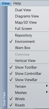
: enable on the Display panel the Diagram (left) and the Terrain (right)
: enable on the Display panel only the Diagram view
: enable on the Display panel only the Terrain view
: remove the Environment tree-list and the Message panel (bottom).
: show/hide the Repository panel (right)
: show/hide the Environment tree-list
: show/hide the Message box (bottom)
: not available
: show/hide the Main application toolbar.
: show/hide the Runtime application toolbar.
: show/hide the View application toolbar.
: see below
: see below
: show/hide the Wind Areas (if any defined)
: show/hide the Road Network (if any defined)
: show/hide
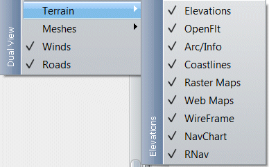
Elevation/DTED layer.
: show/hide Open-Flight layer.
: show/hide Arc/Info layer.
: show/hide Coastlines layer.
: show/hide bitmap and tiled maps layers.
: show/hide imagery from web map services
: show/hide wire-framed layers.
: show/hide Navigation chart (s57) layer.
: show/hide ARINC 424 RNav database layer.
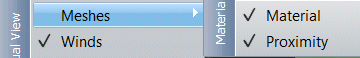
: show/hide
Material based meshes.
: show/hide Proximity type meshes.