Copyright VirtualSim 2004-2020 - All rights reserved
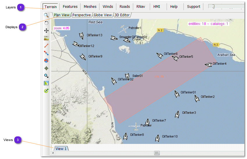
Map Display
The Display Area displays Scenario Map, Features, Meshes or Drawings whose symbols is specific to vsTASKER. The Drawing Area is used to create visually most of the object logic. The point and click paradigm is intuitive for most of the manipulations.
The Vertical ToolBar, left of the Drawing Area shows which objects can be used in the graphical representation. It is context sensitive meaning that there is as many toolbars as environments.
Normal use of the Toolbar is as follow: select the object in the ToolBar then click on the Drawing Area to create it.
Once created:
To select an object, just click on it with the left mouse button or select it in the Environment Tree-List. It turns blue.
To move an object, select it by clicking it then move the mouse while maintaining down the left mouse button. Release the button at end.
To deselect the current selected object, simple click anywhere on the drawing area.
Multiple selection can be performed using the left mouse button. Depress the left mouse button without selecting anything then move the mouse to define the region. A dashed rectangle displays the region. Depress the mouse button to activate the selection. All objects inside the select area are selected and turned blue.
The map display is used to represent the gaming area. It provides several layers to create and edit different features that will be part of the simulation.
Mouse is used to drop entities onto the gaming area, edit their properties, define trajectories, paths or special zones, assign routines and interact during runtime with the simulation engine.
The map display is also used to design and draw human machine interfaces, using predefined sprites.
Layers
Terrain: basic terrain display including Entities
Features: trajectories, paths, special zones (...) editing
Meshes: edition of plan grids for path finding algorithm
Winds: definition of wind grids areas and wind tubes
Roads: edition of networks for road navigation algorithm
RNav: ARINC 424 air-navigation database drawing
HMI: use of sprites to create graphical user interfaces based on OpenGL/GLUT
Help: display the online help system
Support: display the support page (must be connected to Internet)
Window views. Each of them keeps the zoom and centering, allowing the viewer to switch from one area of the scenario to another, or from one zoom factor to another or both, with several combinations.
Entity tracking mode is also kept, enabling to follow multiple entities on multiples views at runtime.
The number of views can be changed from the Database::Settings::Map menu.