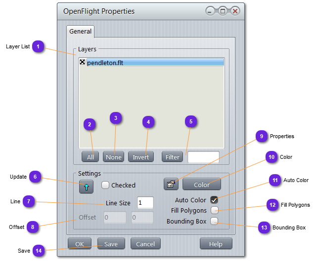
Layer ListList of all the records belonging to the database file.
When a record is checked (x), it will be drawn on the map (visible). When unchecked, it will be hidden.
|
|
 AllCheck all records of the list.
|
|
 NoneUncheck all records of the list.
|
|
 InvertCheck all unchecked records of the list and uncheck all checked ones.
|
|
 FilterSelect only records whose name contains the motif written in the text field.
Deselect all others.
|
|
 UpdateUse this button to update the selected record with the changed values in Settings.
If Checked option is checked, update will apply for all checked records of the list (1) and the selected one.
|
|
 LineDefines the thickness of the line used to display the polygons on the map.
|
|
 OffsetMoves the selected records by (x,y) meters.
|
|
The layer must have been marked as Selectable in the open-flight property window.
| |
|
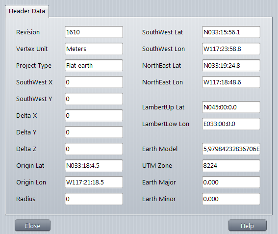
 PropertiesDisplay the properties of the record, as extracted from the original database.
See below:
|
|
 ColorSet the color of all polygons and lines of the record.
|
|
 Auto ColorWhen this is checked, the polygons edges are colored according to their altitude. The redder, the higher.
|
|
 Fill PolygonsWhen checked, all polygons are drawn filled.
|
|
This option is not very useful unless the color is set to very light gray and (11) is checked.
| |
|
 Bounding BoxWhen checked, the layer is marked with a bounding box.
|
|
This can be useful for records that are not displayed in detail but need to be located on the map.
| |
|
 SaveOverwrite the database file with all the changes in the record settings.
|
|