To properly display this page you need a browser with JavaScript support.
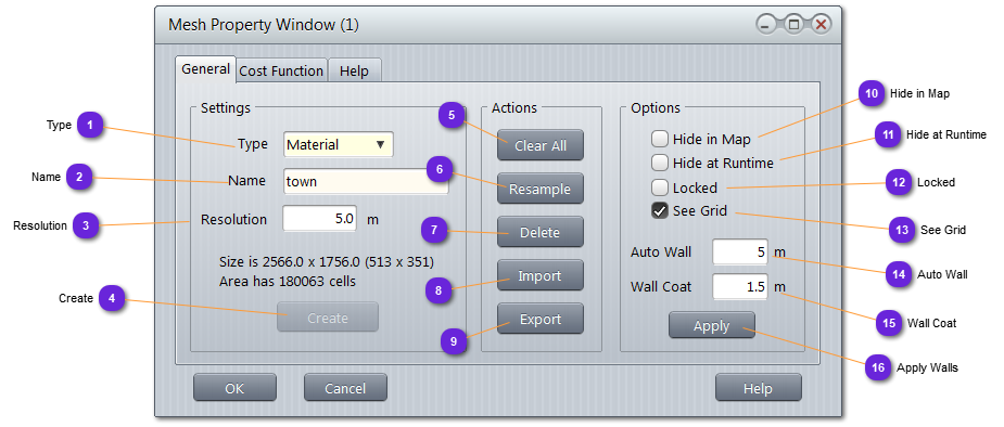
Type Type of mesh:
Material : use to store tag for each node
Proximity : use for entity grouping to accelerate collision and close detections.
Name Unique name of the mesh.
Resolution Width or radius of each node.
For material mesh, the smaller the value, the bigger the mesh and the accuracy of the sampling.
For proximity mesh, it is better to have a reasonable size for a node as too many will reduce drastically the efficiency of the Proximate component.
Create If the mesh has not been created yet, use this button to create it. Will be grayed out at edition.
Clear All Remove all tags or user data from all nodes of the mesh.
Resample If the resolution is changed, the mesh needs to be recreated. Clear All command is called before recreating a new mesh with the new resolution.
Delete Delete all nodes of the mesh, physically, from the memory. You can force the deletion before creating again with the same or a different resolution.
Import Will delete the current mesh and replace it with the selected one from the /data/shared directory.
Export Export the current mesh to /data/shared for later import.
Hide in Map If checked, the mesh and content (for material) will not be displayed on the terrain, even if selected.
Meshes are always displayed when Meshes layer is selected.
Hide at Runtime If checked, the mesh and content will not be displayed on the simulation engine if OpenGL viewer (or equivalent) is selected.
Use this option when Hide in Map (10) is not checked. The mesh will be visible on the GUI map (for info) but not on the runtime window (for performances or other reasons).
Locked If locked, the mesh cannot be displaced with the mouse.
See Grid When checked, the center of each node is mark with an orange cross. It materialize the density of the node.
Auto Wall To be used with popup menu command.
Specify the minimum height step (up or down, in meters) which represent an insurmountable obstacle for the path finding algorithm.
Wall Coat To be used with popup menu command.
Specify the width (in meters) of the No Walk tag area around walls.
Apply Walls Clear all tags of the Mesh (same as Clear All (5) or popup menu ),
call the wall detection procedure using Auto Wall value (same as popup menu ),
secure the walls using the Wall Coat value (same as popup menu ).