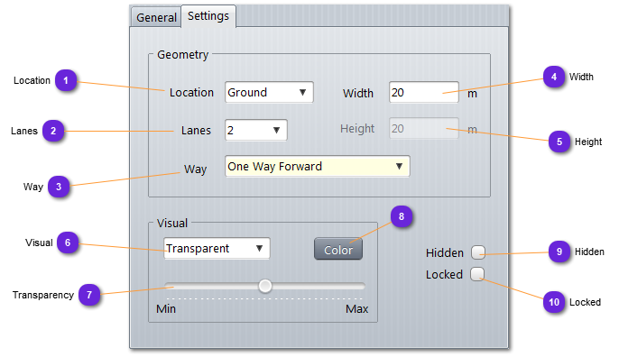
LocationSpecify if the road is on the ground or in the air.
-
: if selected, the terrain altitude will be used for all points of the strip road.
-
: user will need to specify altitude for each strip points.
|
|
 LanesNumber of lanes for the road, from 1 to 5.
|
|
 WaySpecify the orientation of the traffic on the road:
-
One way Forward: all lanes are used forward from first point to last.
-
One way Backward: all lanes are used backward from last to first.
-
Two ways: half of the lanes are used forward and the other half used backward.
-
No way: cannot pass whatever the direction.
|
|
 WidthWidth of the road (including all lanes).
|
|
 HeightFor air road only, altitude of the road.
|
|
 VisualDefine the drawing mode of the road (strips):
-
Outline: borders of the strips only
-
Opaque: strips are filled with the selected color (8)
-
Transparent: strips are filled with a transparent (9) selected color (8)
|
|
 TransparencySet the transparency value of the color used to fill the road strips.
Min for opaque and Max for glass (invisible)
|
|
 ColorColor used to draw the road strips.
|
|
 HiddenWhen checked, the road is not drawn on the map.
|
|
 LockedIf checked, the road cannot be modified. All points are locked including altitude.
|
|