Roads
Road network is a functionality to simulate traffic or connections between nodes, along ways, under constraints.
Although roads can be used for something else than vehicle traffic, it is mostly intended for that purpose.
For air traffic, see RNav.
Maritime routes is not covered yet.
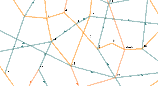
A road is made of strips and points.
A point can either be a road point joining two strips, or a junction point when another road is crossing.
Roads can only be defined (and modified) under the Roads panel:
Components used with road network:
RoadFinding: use the Dijkstra algorithm to find the shortest itinerary in a graph
RoadFollow: make an entity follow an itinerary found by RoadFinding component.
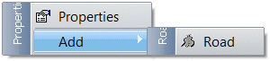
 Add a new road on the scenario.
: create a road on the scenario.
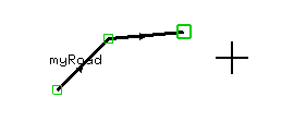
When adding a new road, enter the intended name of the road.
Cursor will change to +
Click on the map to add all road points, from the first to the last one.
When finish, use the mouse right click and select Done.
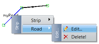
To edit a road, just double click on it or select it and use the Road menu:
: popup the road property window.
: remove/suppress the whole road.
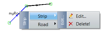
To edit a strip (lane between to points), use the strip menu:
: popup the strip property window.
: remove/suppress the strip. Road will be disconnected.
To edit a point (strip extremity), use the point menu:
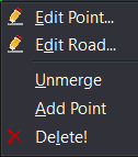 : popup the point property window.
: popup the road property window.
: when a point is an Intersection, will create two (or more) separate points. Roads no longer intersect.
: cursor will change to +. Clicking on the map will add a new point at the mouse location. A strip will be created to join the selected point with the new one.
: remove the point and the connecting strips.
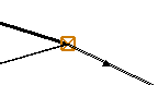
To add a junction or to create an intersection between roads, select a road point with the mouse and drag it over another point of any road.
The cursor will stick to the anchoring point.
Release mouse button. A message will ask permission to merge the two points.

Choose .
A junction point (intersection) is then created and drawn with a brown color:
To unmerge an intersection point, select it, right click and select the option.
|
|
Road strips cannot make angle less than 45 degrees. Position will be refused. Try to put more RoadPoints to round the road and avoid sharp angles.
|