To properly display this page you need a browser with JavaScript support.
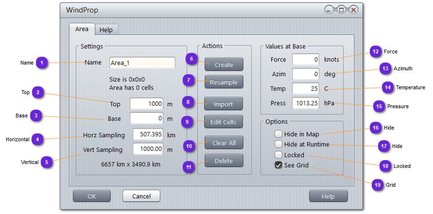
Name Name of the area. Also used to be retrieved from the wind manager.
Top Ceiling altitude of the area bloc, in meters.
Base Bottom altitude of the area bloc, in meters.
Horizontal Set here the width the wind cell.
The number of rows and columns of cells are automatically computed according to dimensions of the bloc and this information is displayed below the name.
Vertical Set here the height of a desired wind cell.
The number of storey is automatically computed according to height of the bloc.
Create Once the parameters are defined in the Settings box, use this button to physically create the wind bloc in memory.
Resample Free the wind bloc from all wind cells and recreate them according to data in Settings box and sampling values.
Cells will also get the Force , Azim , Temp and Press values.
Temperature and Pressure will be modified according to altitude.
Import Create automatically a wind area from a formatted weather grid ASCII file :
Lat [deg] Lon [deg] Alt [m] Wind N [m/s] Wind E [m/s] Temp [K] Pressure [Pa]
Each entry in the file, all separated with space or tab, represent a wind cell.
Edit Cells Call the
Cells Editor for the selected column of the area (shown in magenta on the Wind Area grid)
If no column is selected, the button is not effective.
Clear All Clean all data from all wind cells.
Delete Delete all wind cells, free the memory and remove the area from the scenario.
Force Wind force value at base . The higher the value, the longer the arrow.
Azimuth Wind azimuth value in degrees at base to give to all the cells of the area.
The wind force arrow shows the azimuth, up for north, right for east, and down for south.
Temperature Mean temperature at base of the area.
Temperature will be automatically adjusted according to altitude gain (6 degrees loss per 1000 m)
Pressure Mean pressure at base of the area.
Pressure will be automatically adjusted according to altitude according to the following formula: p(z) = 1013.25 * (1-(0.0065*z/288.15)) ^ 5.255
Hide If checked, the wind area will not be displayed on the terrain, even if selected.
Wind areas are always displayed when Winds layer is selected.
Hide If checked, the mesh and content will not be displayed on the simulation engine if OpenGL viewer (or equivalent) is selected.
Use this option when Hide in Map (10) is not checked. The mesh will be visible on the GUI map (for info) but not on the runtime window (for performances or other reasons).
Locked If locked, the area cannot be displaced with the mouse
Grid When checked, each node is drawn with a square (plan view) or a cube (perspective view).