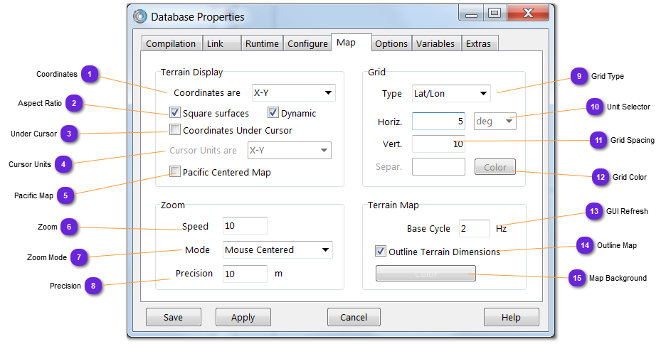
vsTASKER is using flat earth projection meaning that on WGS84 maps, distortions are noticeable on high latitudes.
Square surfaces can be selected to avoid some vertical shrinking. The aspect ratio used is 1, meaning that drawing a circle will keep the distance on latitude and longitude over the map and its shape will not be oval. Select this mode when drawing 2D figures designed for flat earth projection (like Circle and Rectangle Special Zones)
If Dynamic is selected, the aspect ratio will be computed according to the latitude of the center of the view. This mode can produce higher distortions on borders when viewing large areas but provides better accuracy on high zooms, around the center of the viewed zone.
When the Under Cursor mode is selected, the coordinates unit is selected here. It can be different from the Map coordinates (above) for comparisons reasons or to display more usable value (Lat-Lon decimal).
Select the type of grid to display on top of the terrain map display:
None: No grid displayed
Cross: Single cross with a square defining the boundaries of the terrain map
Grid: Vertical and Horizontal lines over all terrain but inside the square defining the boundaries of the terrain map
Lat/Lon: Latitude and Longitude lines are drawn according to the setting, in degrees
Circular: From the center of the map, circular rings separated by the radius value are drawn. According to the type of coordinates selected, flat earth or WGS 84 projections are used.
The plugin DLL displaying the grid is located in /plugins/grid (GridDraw.cpp) and can be changed (or replaced) by the user.
In case of change, keep in mind that the successive product releases will overwrite the module. It is advisable to duplicate the module (myGridDraw.cpp), recompile it and use the generated myGrid.dll into the plugins definition window.
Set here the refresh rate of the Map/Terrain display at runtime.
The frequency shall be in accordance with the Export Component Model frequency. If the Export is running at 5hz, the Map Base Cycle shall be set up to 5hz. A higher frequency will increase the CPU load without any visible effect on the Map.
A high frequency might impact the GUI response time.
When selected, the terrain dimensions will be drawn (outlined). Deselect this option to hide it.
The terrain dimensions (width and length) are used to delimit the gaming area, inside a maybe much bigger map or terrain. It is useful to see the limits as much as to hide them.
Set here the color requested for the Map terrain (OpenGL) background.
The background is the visible area not covered with any layer or visible beneath vector layers.
When two or more vsTASKER GUI must be displayed on the same computer (distributed simulation test), it is a good idea to change the color of the Map background to quickly differentiate each of them.