To properly display this page you need a browser with JavaScript support.
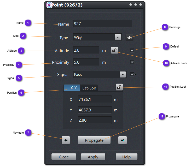
Name Name of the point.
Type Display the type of the point:
Intersect : intersection point of more than 3 strips.
Way : connecting point of two strips or extremity point of a road.
Altitude Altitude of the point.
If the road is grounded, will be altitude of the terrain below the point.
Proximity Used by the RoadFollow component.
A point is considered passed or reached at the following distance.
Signal Used by the RoadFollow component:
Type of the signal or behavior for a point/junction.
Pass : default value for all point that are not intersection.
Stop : entity will stop and wait for other strips to be cleared before continuing the itinerary.
Yield : entity will yield the way on the other strips before continuing.
Crossing : right priority will apply.
Traffic-Light :
not implemented yet.
Position Coordinates of the point in XY or Lat-Lon.
Navigate Use these buttons (right and left) to navigate the road from one point to the next one successively, forward and backward .
Unmerge If the point is used in a junction, pressing this button will isolate it and create intermediate points for all shared strips
Default Check this to make the data default one for Propagate function.
Altitude Lock Lock/Unlock the altitude. Useful for ground roads to prevent automatic change of the value. Once a road (or individual point) is locked, the altitude of all its points will remain unchanged.
Position Lock Lock/Unlock the position. Useful to prevent accidental move of a road point. Once a road (or individual point) is locked, the position of all its points won't be modifiable.
Propagate Will propagate to all points of the road the values checked as default (9)