Terrain layers (see
here) are displayed on the
Map panel, for each selected (activated) scenario.
Drawings are using OpenGL and
plugins.
Mouse must be used to select any entity or plan point drawn on the map.
Depress right mouse button (and hold) while moving the mouse to pan the terrain.
Use the mouse wheel to zoom in and out.
Depress left mouse button (and hold) while moving the mouse to select on the terrain.
Plan View is the default God eye view.

on the map (cursor changes). Click and select the area you want to zoom at.

zoom (goes back to optimal terrain view)

Allow of the terrain without using the right mouse button

Activate/Deactivate the on the map.
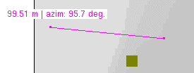
Click on the tool, cursor changes to symbol +. Click on the map and (with mouse button down) move the mouse to define the measurement string.
Distance and azimuth are displayed on the map (see below).
When tool is activated (mouse symbol +), string extremities can be reselected and moved.
Extremities can also be dropped on entities and automatically hooked (this allow measurement between to entities, even at runtime).
To remove the string, just click on the map and release.
Click again on the tool to deactivate it.
To activate this functionality on the OpenGL or GdiMap display, use CTRL I key or the following code:
|
ogl_draw->mouse.mmmode = M_String; // activate
ogl_draw->mouse.mmmode = M_Void; // deactivate (or ESC)
|

Activate/Deactivate the l (LoS) string on the map.
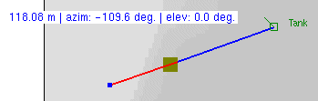
Click on the tool, cursor changes to symbol +. Click on the map and (with mouse button down) move the mouse to define the LoS string.
The extremity of the string are dropped on the ground below it. The color change (blue/red) at the point where the terrain is blocking the view.
Extremities can also be dropped on entities and automatically hooked (this allow visibility between to entities, even at runtime).
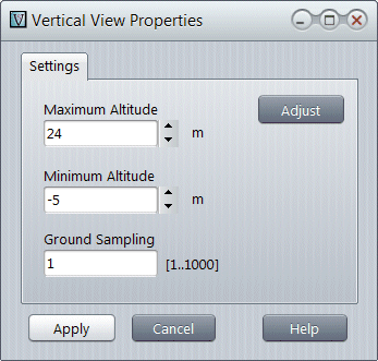
Vertical view is also displayed with the associated setting window.
You can change the Ground Sampling parameter to increase/decrease the accuracy of the visibility check.
To remove the string, just click on the map and release.
Click again on the tool to deactivate it.
To activate this functionality on the OpenGL or GdiMap display, use CTRL L key or the following code:
|
ogl_draw->mouse.mmmode = M_LOS; // activate
ogl_draw->mouse.mmmode = M_Void; // deactivate (or ESC)
|

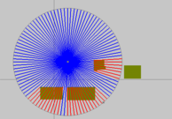
Activate/Deactivate the (AoS) fan on the map.
Click on the tool, cursor changes to symbol +. Click on the map to define the fan center and (with mouse button down) move the mouse to define the fan size.
The center of the fan is dropped on the ground below it. For each sector, color change (blue/red) at the point where the terrain is blocking the view.
Fan center can also be dropped on entity and automatically hooked (this allow ground coverage by the entity, even at runtime).
To remove the fan, just click on the map and release.
Click again on the tool to deactivate it.

Activate/Deactivate the of the selected entity. The map will automatically centered on the map (useful at runtime).
To activate this functionality on the OpenGL or GdiMap display, use CTRL O key or the following code:
|
ogl_draw->mouse.mmmode = M_AOS; // activate
ogl_draw->mouse.mmmode = M_Void; // deactivate (or ESC)
|

Use to change the of all entity symbols symbols
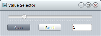
Use the slider to size up (right) or down (left) symbols on the map.
Reset will revert the factor to 1 (default).

Same as entity popup menu option
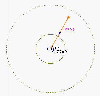
.Displays the azimuth line (orange vector) and the speed selector (blue anchor).
Grab the orange anchor with the mouse and turn it to set the heading.
Grab the blue anchor with the mouse and slide it to change the speed.
Plain and dashed circles represent minimum and maximum speed for the entity.
Click anywhere to quit the mode.